Over the last few weeks I have continued to work on the map that I started here. When I began I didn't realize what an epic undertaking it would be. It has over 550 layers and the photoshop file is nearly 600MB in size. It's been pretty exhausting and it still isn't finished, but hopefully by next week I'll be done.
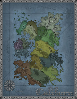
First I'll start by showing you where I left off. This picture on the right was the last version of the map that I had posted. I had just finished drawing the political lines and layering the shields on top of each kingdom to mark which was which.
Since then I've had to change the political lines (twice) which was a bigger pain that I realized it would be. I also added mountain ranges, hills, forests, and rivers. Many of these natural features provide markers where one kingdom ends and another begins.
Labeling is still a work in progress. The major seas, Lochs, Firths, and straights have been labeled; the mountains, a few passes, some marshes, and major hills also, but so far no cities, towns or castles have been put down or been labeled. The forests and lakes also need labeling, that being the next step I plan on taking.

To the left is the most current version as described above. As I said the political lines are slightly different though each kingdom is in more or less the same place. This represents a good bit of work, and though I think it looks to be coming along well, I would appreciate some feedback.
I was messing around with various filters and came up with this alternate version of the map in sort of a faded monotone look. I don't think I'll use it, but it looked kinda cool so I figured I might as well share it.

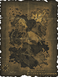
Finally this last version of the map is what I call the Pirate Treasure map version. Don't think I'll use this style either, but I love treasure maps.


8 comments:
I like them all. The treasure map one is especially cool I think you should use it.
Very nice. Love the shields. And the coastlines are great.
What technique do you use for drawing the coastlines?
LeftBHind - Thanks, I'm glad you like them all. I like the treasure map looking one too, I just don't know that it fits with everything else I am making for the game. I still think it came out great though.
Greg - The coast lines were made using a great technique employed by many a photoshop cartographer. What you want to do is create a base layer and fill it with clouds (Filter>Render>Clouds). Next create a layer on top of that and use the fill option to make it completely gray (Edit>Fill>50% Gray). Finally use the paint brush tool to paint in your landmasses and seas. Adjust the opacity of your brush as needed.
Please feel free to email me if I can be of any further assistance!
Wow. These maps are incredible. I relinquish my cartographer crown to you, sir!
I feel like you could probably merge some layers to make it a smaller file though. Sometimes I regret an early merge, but huge files make my photoshop craaawl.
Excellent, Excellent job!
I must be missing something, Labyrinthian. Am I using an eraser brush to cut into the gray layer? Am I supposed to be applying layer effects? Because when I follow your instructions, I just end up drawing with a black brush on top of a gray background, which is sitting over an unused cloud layer.
What am I missing here?
Oops! You're missing the part where I explain that the gray fill layer must be set to 'hard mix'
Once you have it the way you like you can merge the layers together.
Holy hell! That is awesome.
Dude, I am so psyched about this technique. Simple as can be, yet awesome.
Will definitely keep coming back for more goodies in the future.
Post a Comment